Sunday, May 30, 2021

Cicadas

 Here in Virginia we are in the middle of the Brood X periodic cicada emergence. Every 17 years the insects which make this brood up emerge from the ground, try to climb a tree (or fence, or house, or car, or whatever they can find). Upon emergence, they have no wings. Shortly after they exit the soil, their exoskeleton hardens, often while they're grasping a tree or fence. Then the exoskeleton splits open as they molt and the cicada emerges with stubby wings, leaving the exoskeleton behind, often still attached to a tree or fence. The wings grow quickly, the insects darken in color, then they try to fly/climb to the tops of the trees. Then they make an awful racket as they attempt to mate. Then the females cut slits in tree/shrub branches, and the adult cicadas die. Eventually the eggs hatch, the hatched nymphs fall to the ground, they dig into the soil, and they live there for 17 years, when they emerge from the ground and the cycle starts again.

This is the second time I've seen the emergence in Virginia. Just like last time, these insects are everywhere for a few weeks. They're on the sidewalks, in the air, and sometimes they land on me. They are all over my yard, roses, fence, and trees. The bugs are everywhere. The empty shells are everywhere. No bird or rat is going hungry right now. Cicadas emerge in such enormous numbers that it does not matter to the population that many of them die before procreating.

Why am I writing about this? Because I tried my hand at macro photography, using them as the subject. They're slow-moving and easy to find right now. I used a tripod, a 70-200 f2.8 lens, and an extension tube for close focusing. This makes the focal plane extremely thin, which makes it hard to get a sharp shot. So there's the challenge. Here are some results.

On my roses

On my roses

Climbing

Just emerged from the exoskeleton

Bulging red eyes


Sunday, February 21, 2021

Cygnus NG-15 Launch

Every now and then NASA sends a resupply payload to the International Space Station. Some of the missions launch from the Midatlantic Regional Spaceport (MARS). My wife and I sometimes go watch the launch when the date/time is convenient.

We usually drive to Chincoteague and park on/near the causeway that leads to Assateague Island. There's a good view from there to the launch site.

While it's fun to watch this, photography is hard. The pad is several miles away, visible in the distance. Even on a cold day (like yesterday) there is a haze that makes sharp photos impossible.

Launch
The atmospheric distortion can even make the rocket itself look bent.
Distortion
As the rocket climbs, the air through which I'm shooting is cleaner and less disturbed, but by then the rocket is farther away so it appears smaller. This is also when the noise of the launch finally reaches the causeway. The roar is not loud, but lasts a while, even as the rocket disappears.
Climbing
Eventually the rocket gets far overhead and fades away.
High Up and about to Disappear from View


I was ready for the cloudy contrail this time. But, there was no nice pretty trail to shoot.

Sunday, January 3, 2021

Hawaii Vacation During the COVID-19 Pandemic: Part 2

Well this trip is over. Sadly, it's back to Virginia.

My wife and I have been thinking about where to live when we retire. Neither of us wants to go back to the place where we grew up (Louisiana for me, Massachusetts for her). Neither of us wants to stay in Virginia. Hawaii is looking good...

There's a lot to worry about in a move to Hawaii: it's expensive, there are earthquakes and tsunamis, it's remote so we won't get many visits from relatives, health care options are limited except for Oahu. The Big Island has its own issues. Most of the island is susceptible to lava flows and the associated destruction of anything it its path. Recent volcanic activity has been on the east side of the island in the eastern rift zone, but there have been active lava flows on the western side of the island in the last 100 years. During the Kilauea eruptions of the last 50 years, volcanic gases (vog) can hang around and create bad air quality on the eastern coast.

There's a lot to like about Hawaii: great weather, beaches, mountains, jungle, desert, and active volcanoes. Yes, the active volcanoes are dangerous and fascinating. They give and they take away.

It's good that we came here this time: we got to see vog. We got to see weather that we hadn't seen on our previous 3 trips to the island. We explored roads and neighborhoods to get to know the island better. In short, we're more convinced than ever that the Big Island will be our retirement home, if we meet our savings targets and stay healthy.

Now about visiting the island during the pandemic...

We had to have negative COVID-19 tests prior to boarding the flight to Hawaii. Then we got tested again at the arrival airport. Then we had to present our negative COVID tests to rent a car. Then we had to present our negative COVID tests to check in to the hotel. And for the most part, that was it. We were able to travel the whole island without restriction. The beaches were open (with a group size limitation). The restaurants were open. Most people were wearing masks, except when swimming or exercising. Only one restaurant (in Hilo) cared about our COVID tests. We had to wear our masks in restaurants, except when seated at our table. The trip back was uneventful. We wore our masks, social-distanced, and got home jet-lagged and glad to have made the trip.

Some trip highlights:

  • We saw a monk seal. Four times. On two different beaches. I'm not sure if all four sightings were the same animal. I previously thought that monk seal sightings on the Big Island were rare, in the single digits per several years. I now know from talking to the volunteer monitors on the beaches that a small number of individuals have been hauling out regularly.
  • We saw lots of green sea turtles. Like the monk seals, they are protected by law. We kept our distance from seals and turtles as required.
  • We made a deliberate decision to try more local food. The Seafood Bar and Grill in Kawaihae and Cafe Pesto in Hilo both served excellent meals. My favorite is seared poke in Kawaihae.
  • We wanted to see how things are in Pahoa, two years post-eruption. Some of the roads have been rebuilt. It was weird to see the end of Pohoiki Road near the Lava Tree State Park. The road is buried under a solidified river of lava that must be 30 feet thick. We also drove some of highway 137 along the coast. It's still remote, beautiful, and in danger of more lava. Living there is an exercise in having a beautiful place that could be destroyed in the next eruption.
  • Speaking of eruption, we were able to visit the Kilauea summit just as the Halema'uma'u crater was filling up with a new lava lake. 
I didn't do a lot of photography this trip. Some of my favorites are...
Sunset

Sailboat at Sunset

Monk Seal
Monk Seal

Monk Seal

Sunset

Sunset

Surfer at Sunset


Black Crowned Night Heron

Green Sea Turtle

Green Sea Turtle and Monk Seal

Halema'uma'u Glowing with Lava

Friday, December 25, 2020

Hawaii Vacation During the COVID-19 Pandemic

My wife and I plan our vacations with long lead times. Sometimes we have plans for a vacation more than a year from now. This helps us get good travel deals and allows us to give our employers plenty of notice. We planned a trip to Hawaii before we had ever heard of COVID-19. We had also planned a July vacation in Iceland. And I had planned to cycle across Iowa in RAGBRAI 2020. We cancelled both of those trips. Or, more accurately, they were cancelled for us. Back to Hawaii... 

As the date of our trip approached, we considered cancelling. The COVID infection rates seemed to decrease over the summer, only to worsen as winter approached. Should we stay? Should we go? 

 The state of Hawaii imposed strict testing/quarantine requirements as the government allowed businesses to reopen. It was possible to make the trip, but should we? I study things that interest me. A lot. I don't want to get sick. I don't want my family to get sick. Whether staying home or travelling, I wanted to know what to do to improve my chances of staying healthy. How does one get sick with COVID? How can we protect ourselves? 

Bottom line: To get sick, one has to stay in close proximity to an infected person who is talking, singing, coughing, or breathing heavily (perhaps while exercising) for some number of minutes. Keep your distance, and you're safe. Can't keep your distance? Like passing someone in a store aisle or on a sidewalk or in a hallway? Make it very brief, and you're safe. How about masks? As far as I can tell, and this is based on a lot of reading and talking with health professionals, a mask won't protect you. Why wear one? A mask wearer's mask will trap a large fraction of the droplets that are expelled when coughing, talking etc. In short, a mask protects everyone EXCEPT the wearer. And while wearing a mask, you are less likely to touch your own face. If an infected person contaminates a surface, and you touch that surface, you are less likely to then touch your own face when you have a mask, so there is a small benefit to yourself when you wear a mask. 

In light of that analysis, what is the best course of action? We have to continue our lives and work. We have to go to the store, job site, doctor's office. We have to exercise and maintain the house. Life does not stop during a pandemic. The pandemic imposes a requirement to be careful, to be smart about what we do, but it does not mean we have to shut ourselves up inside. At least COVID-19 does not impose a requirement to cower at home. In my judgment, the most dangerous part of a trip to Hawaii is the time in the airport and on the airplane. We took our COVID tests, got our (negative) results, and flew to Hawaii. We wore masks in the airport and on the planes. We social-distanced as much as possible in transit. We got off the plane, showed our negative COVID test results, then promptly got tested again. Then to rent a car, we had to show our negative COVID tests. Then when we checked in to the hotel, we had to show our negative COVID tests. 

As I write this, I'm on the balcony watching the surf crashing. There are surfers playing in the waves. I saw a pod of dolphins swim by earlier. What's it like on the island during the pandemic? Lots of stores are closed. Traffic is lighter than I've seen in my four trips to this town. Everyone wears a mask in the stores. The tourist sites are still popular, but not crowded. We've travelled a lot around the island; we are NOT required to quarantine. We wear masks and keep our distance. And we're having a peaceful vacation. 

The last time we came, the Kilauea volcano had just gone through an increased phase of eruption that destroyed 700+ homes. But by the time we arrived, there was no eruption any more. That pause lasted two years. Hours after we arrived on this trip, a new eruption started. We were able to visit the Kilauea summit to see the beginning phase of the eruption as the summit caldera has a new lava lake forming. Along with several hundred other people, we went to the edge of the caldera as night fell and watched the cloud of gases rising as the glowing lava illuminated the crater walls and the cloud.
Kilauea/Halema'uma'u Eruption

The Kaloko-Honokōhau National Historical Park is near Kona. I went there several times last trip because it's a good spot for turtles and sunsets. On my first trip there this week, I was pleasantly surprised to see a lot of turtles AND an extremely rare monk seal. In fact, the monk seal was playing in the surf with a green sea turtle.
Monk Seal and Green Sea Turtle

I had so much fun watching the seal, I went back the next day. Unfortunately the seal wasn't there. But the sunset was wonderful and a surfer passed right in front of the sun at sunset.
Surfer at Sunset
Stay safe; stay healthy; Aloha!

Saturday, November 14, 2020

Conowingo Dam

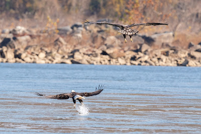
It's November; it's time to go to the dam. The Facebook groups have lots of really good shots lately so I decided to go to the dam today. The COVID-19 pandemic is rapidly getting worse so Exelon is not running shuttle service. Get a spot to park, or leave. I arrived at 5:30AM and there were only a few spots left. All of the spots on the concrete balcony were taken. All of the spots along the fence that were unobstructed by trees were taken. Even my preferred spot on the rocks by the water was lined with fishermen and photographers. At 5:30AM! I grabbed my gear and carefully scrambled on the rocks in the dark and found a spot. And I waited. And waited. And waited. Finally the sun started to rise. I had a beautiful look at a mid-air eagle fish fight. It was really close. But it was still dim and in the direction of the sun; there was no way to shoot it. Overall, it was a pretty slow day. There were lots of eagles in the trees behind the parking lot, and a few dozen on the rocks on the far side of the river. But most of the action was the constant black vulture flying. Even the cormorants were reduced in numbers. However, I did get some keepers. I was glad that the last sequence before I left for the day resulted in some usable shots where an adult eagle caught a fish and a juvenile was on his tail to steal it before the fish was even out of the water.

Thursday, August 13, 2020

Bigelow Preserve Hike

My son and I hiked through the Bigelow Preserve in Maine. I've wanted to try this hike for years and we finally did it. 

Here's a view looking north at Flagstaff Lake with scattered cloud shadows:

Panorama Looking North from the Summit of Bigelow Mountain

Let me set the stage.

My in-laws have a vacation home in Maine. The Appalachian Trail passes nearby. Over the years, I've passed the Stratton trailhead dozens of times while driving highway 27 through the Carrabassett Valley. The north side of the valley is dominated by the Bigelow Preserve. The south side is dominated by Sugarloaf Mountain.

I prepared for this hike as follows:

  1. Last year, my son and I hiked part of this trail by parking in Stratton and climbing on the trail to Cranberry Pond. This was about 4 miles in, then back out by the same trail. We had seen 4 miles of the trail.
  2. I reviewed the topographic map of the trail. I knew that there would be several significant climbs.
  3. I read trail reviews online. The trail length was reported as just over 16 miles.
  4. My normal walking pace is about 3 mph. I planned for 2 mph on this trail for a duration of 8 hours.
  5. My son and I scouted the trailhead at Long Falls Dam Road. This was to be our entry point.
  6. My wife, son, and I went looking for moose near Stratton. On the way, I showed my wife where the Stratton trailhead was located so she could pick my son and me up at the end of the hike.
  7. I packed a backpack with food and drinks that I expected to be enough for the trip.
  8. There was a storm with torrential rain. I waited 2 days for the trail to dry out.
I don't hike often, but I've done a significant amount. I've hiked up/down mountains in the Alps. I've hiked up/down mountains in Shenandoah National Park. I hiked through Haleakala caldera with my son. Just 8 months ago, I hiked the Nā Pali Coast and the Sleeping Giant trails on Kauai. I ride my bike. A lot. My son is in Army ROTC. He works out. A lot. We're both active, in good health, and have hiking experience.

Here's what went wrong:

  1. Before leaving on vacation, I looked all over the place for my Sawyer water filter. I couldn't find it. I hit the trail without it. And of course this means that, even though I packed a lot to drink, we ran out. Well, not really, but almost.
  2. After my wife dropped us off at the Long Falls Dam Road trailhead, we encountered a sign that said the distance to the Stratton/Highway 27 trailhead was 17.8 miles, not the 16 I had expected.
  3. Much of the trail was very rocky, not at all like the 4 miles that we had already seen. Our progress slowed.
  4. I had a cell phone signal for about the first half of the hike, then nothing. I texted my wife that our pace had slowed and told her to wait an additional 2 hours before picking us up.
Here's what went right:

  1. The views are stunning. Looking north, all of Flagstaff Lake is visible. Looking south, we were treated to a great view of Sugarloaf Mountain and the airport in the valley.
  2. We had plenty of food.
  3. The weather was wonderful.
  4. The trail was mostly dry.
  5. My new Garmin watch was very helpful in keeping situational awareness: how far we had gone/climbed, pace. After the hike, it was very interesting to see the stats and track.
We made the first climb. It was strenuous. We were rewarded by great views. We descended, then ascended to the highest peak. Once again, we had stunning views. I told my wife that we would take 10 hours from the start, not the 8 that I had projected. Then the trail got much harder, just as I lost the cell phone signal. We slowed way down because of the trail conditions, and we were about half way to our destination, and we had gone through more than half of our water.

We came upon a hiker who was filtering water at a spot on the trail. It was clear to me that we would run out of water, so I asked him for a favor: I explained the situation and asked if he would filter some water for me and my son. He agreed and gave me more water than I was hoping for. His trail name is Mud Crack. Thank you Mud Crack! My son and I actually reached the end of the trail with a few ounces of water left, thanks to you.

OK, long story short: my son and I pressed on, made the two remaining climbs and descents, and got really tired. There were two more events of note. The sun went down behind the peaks and suddenly we were in shadow. I began to worry about running out of daylight. We were much slower than expected and we were on the shaded side of the valley. I had not expected to still be on the trail and had not brought a light. The trail got better and we picked up the pace as best we could. When we finally reached the trailhead, we were four hours later than originally projected, and two hours later than our rescheduled arrival. My wife had gotten worried and went to check a nearby trailhead to see if maybe we had gotten lost. My son and I arrived at a deserted trailhead, with no cell phone signal, and could only wait. She showed up after about 10 minutes.

OK, lessons learned:

  1. I'm not hiking again, at least not for a day trip this long, without a water filter.
  2. I'm not hiking again, at least not for a day trip this long, without a flashlight or headlamp.
  3. If I hike this section again, I will get to the trail head at sunrise (we got there about 60 minutes after sunrise and I'll plan on 12 hours, not 8).


Wednesday, August 12, 2020

Maine Moose

I'm fortunate to be able to take vacation in Maine almost every year. When it's uncomfortably hot and humid in Northern Virginia, it's great weather in Maine.

When we (my family) and I are in Maine, we always look for moose. They're unlike any animal that I see in Virginia. There's a highway between Stratton and Rangeley. Moose frequently graze along the side of the road as the sun is setting. This year we saw three moose during our trip on this road.

The first moose disappeared into the woods almost immediately after we saw her. The second moose was down in a ditch, partially obscured, hard to get good shots of. Here's the best of the sequence.

Cow Moose Looking at Me
Cow Moose
We drove away, leaving this moose behind. Farther down the road, we saw a bull that was standing in a shallow stream. By the time we saw him, we were already past, so I found a safe spot to turn around and went back. By this time the moose had moved closer to the road. We had several minutes to observe this animal as he came closer to the car. I even had the impression that he was going to come close to the car to check us out. As he crossed the road (we were stopped on the opposite side of the road), another car approached and spooked him. He ran into the woods.
Bull Moose Crossing the Road
Bull Moose
On another day, my son and I also had a rare middle of the day sighting while we were scouting the trailhead for a hike we were planning. We rounded a bend in the road and saw a bull on the road. I stopped the car and he went into the woods. As we passed the spot where he disappeared, we saw another moose in the woods with him.

On yet another day, as we were driving back to the vacation home, we had a brief glimpse of another moose next to the road.

So, the total for this trip is six. Most years we see no moose at all.