|
| Blue-Footed Booby |
My wife and I visited the Galapagos Islands in February. This was my first trip to South America and my first time in the Southern Hemisphere (although not very far into it). The Galapagos Islands remind me of the Hawaiian Islands, at least with respect to geology. They also have similar invasive species problems. This was a fantastic trip, with wildlife, volcanic features, and wonderful visits to beaches and hills in warm, humid weather.
We flew from Dulles Airport to Quito on Copa Airlines, with a stopover in Panama City. We had a full day in Quito, during which we rested and walked to the nearby botanical garden for a visit. In spite of its location on the equator, Quito was cool and damp because of its high elevation.
After our day in Quito, we took a bus, provided by the cruise line, to the airport. We had to put our luggage out the night before for invasive species inspection and sealing. At the airport, we had to go through hand luggage inspection in addition to security. We flew Latam Airlines to San Cristobal Island, with a stopover in Guyaquil. The airport on San Cristobal was a typical small-island airport - no jetways, no air conditioning, only one area each for arrivals/departures, and a long line to get through entrance control. Even though this was a domestic flight, we still had to clear passport control and provide documentation that showed why we were there and when we were leaving. After passing through all that, we had to wait, as a group, for all of the luggage to come off the plane, where it was lined up in rows and, when it was all out, a cop with a dog briefly inspected it. The cop selected a few bags for more-thorough inspection and then the rest of us could claim our luggage and leave.
We boarded some hot buses, provided by the cruise line, and made the short trip to the marina. There we waited on the dock for our turn to ride a zodiac to the ship. There were sea lions on the dock, sleeping. There were sea lions on the rocks, sleeping. There were sea lions in the water. There was an iguana running among us, and we had to be careful to avoid stepping on it.
When our turn came, we boarded a zodiac and rode out to the ship, the Silver Origin. There was significant swell, which made getting into/out of the zodiac an adventure, which we repeated twice a day for the next week. Once aboard the ship, we immediately noticed that it rolls, constantly. We’re used to much-larger ships that have better stabilization so this was a surprise. I never got seasick; it was never uncomfortable, but always noticeable. We waited a while for our turn to check in, then went to lunch, then finally got our key cards for our cabin. We unpacked, watched the safety video, went to the muster drill, had a quiet afternoon as the ship departed port, and were quietly sitting in our room when we had our first stop: Kicker Rock. I opened the window to take a few shots from our room.
 |
| Kicker Rock |
This is when we noticed that the AC wasn’t working. It never turned back on after I closed the window, so we had a warm first night. We reported to our butler (that’s what the staff calls them) and he got it fixed while we were on our first outing.
This was an expedition ship, which means it is small, which means there’s also a meeting every night before dinner with a brief educational presentation followed by the activity director’s description of the next day’s activities. I was dubious about the value of these nightly meetings, but the educational info was mildly interesting and the description of the next day’s activities was crucial for making good decisions about what to do.
I used the Apple Journal app on my phone to keep track of what we did each day. I grabbed screen shots of the map at each stop so I had a record of the location of each activity. The ship has good Wifi so I was always able to get good maps.
Our first morning, I went with the “power walk” group to a hilltop viewpoint on St. Bartoloma Island. We climbed (on a boardwalk with steps) to the top of a volcanic cone, where we had a great view of the volcanic features around us.
 |
| St Bartoloma looking toward Santiago |
The ship repositioned during lunchtime to a place off Santiago Island where we had an afternoon zodiac tour of the shore. Then briefings, followed by dinner. This was the pattern for the whole trip: a morning activity, the ship might reposition, then an afternoon activity, then briefings, dinner, bed. Sometimes there was a second morning activity. There were walks ashore, zodiac tours, snorkeling, and kayaking. There was hot weather and hotter weather. There were brief periods of blue sky, mostly partly cloudy days, and some overcast periods. There were torrential overnight downpours. What there wasn’t was a clear sunset or sunrise. And I was hoping for clear nighttime skies to see the dark sky, but we barely saw the stars. Having said all that, we did have good weather for all of our landings except one: a wet landing where the waves picked up as we returned to the ship and I got hit by waves up to my waist and then got rained on.
We also visited Isabella, Fernandina, Floreana, and Santa Cruz Islands. Each island has its own geography, wildlife, and unique places to visit.
After seven nights aboard, we disembarked at the same port where we embarked, saw the sea lions again, rode a bus to the airport, went through security again, and flew to Guyaquil on Latam. We stayed at a hotel in town until midnight, when we went back to the airport for our 3AM flight on Avianca Airlines. We had a stopover in Bogota, then returned to Dulles.
Wildlife seen: Iguanas, sea lions, lava lizards, Nazca and Blue-footed boobies, sea turtles, penguins, porpoises, and tortoises.
Photography from a zodiac in waves was an adventure. Aside from that, landscape photography was pretty good, with good light most of the time. Wildlife photography was also quite easy because most birds, iguanas, and sea lions were unbothered by close approaches. For landings, I used my 70-200mm lens for most shots and rarely wanted a different lens. I kept a second body handy on the ship with my 300mm lens attached and used that a few times for wildlife. I also brought my 24-70 lens, and there were a few times that I used it for interesting landscapes visible from the ship. I also used my phone a lot.
The Silver Origin is a very nice ship. It accommodates up to 100 passengers, with a crew of about 100. Our room was comfortable and quiet. The constant rolling took some getting used to. I frequently had trouble walking a straight line in the halls. During especially severe rolling episodes, the hot tub regularly spilled water all over the top deck, and sometimes the water formed waves in the shower. The dining room food was good. Most nights, we chose to eat in the outdoor grill on the top deck. The expedition staff was very knowledgeable and friendly. We had daily interaction with them. The zodiac drivers seemed to be the hardest working crew members, at least among those we saw. But we never saw their faces until the very last night when the captain introduced the entire crew: the zodiac drivers were always covered head-to-toe to protect them from the harsh sunlight. All we saw of them was clothing and sunglasses; even their faces were covered. Every time the ship stopped, the zodiac drivers immediately launched boats and took the expedition leaders out to scout the area before taking passengers. The zodiacs were constantly on the move until the last people came back aboard after a stop. Then the drivers loaded the zodiacs back on the ship. First out, last in. I’m sure the kitchen staff works pretty hard too. The crew was diligent about making sure we always had life vests on when we left the ship, and we had to swipe our room cards every time we entered/exited. We were invited on a tour of the bridge. It was very interesting to see how highly-automated it is.
Here’s a sample of the many photos I made on this wonderful trip.
 |
| Mating Tortoises |
There was only one trip ashore that required getting on a bus: visiting the tortoise refuge. There were tortoises everywhere. Mating is apparently an hours-long event with very little movement.
 |
| Yellow Warbler |
Galapagos Giant Tortoise
Silver Origin
The Silver Origin tours the Galapagos Islands only. They store about five zodiacs on the bow deck and hoist them onto/off of the ship at stops. There are also doors on both sides of the ship from which they launch more zodiacs. At the rear of the ship, there’s a large platform near the water line that they raise to form a wall while under way but lower to form a landing for the zodiacs. There’s no theater or stage; there are no shows for entertainment, there’s no casino, and only two places to eat. This was not a relaxing trip. There was very little time during the day when nothing was happening. If you want a typical cruise experience, this is not your boat. I really liked the small boat experience and I would gladly go on another cruise like this one.
 |
| Land Iguana |
On our last full day on the ship, we visited the one place where we saw land iguanas. It was a hot, muddy walk ashore where we saw lots of these animals feeding in the bushes. When we returned to the ship, the crew asked us to take our muddy shoes off and leave them on the deck. They washed all of our shoes for us. Of course this wasn’t them being nice; they didn’t want us tracking mud into the interior of the ship. They also encouraged us to jump into the ocean and swim to waiting zodiacs nearby (also washing mud off of our bodies). The warm ocean water was nice, and surprisingly not very salty.
 |
| Blue Footed Booby |
There were Blue-Footed and Nazca Boobies everywhere. The closest approaches were while riding on zodiacs, making photography a challenge. Even though we got very good looks at them, my photos are all underwhelming. When riding in a zodiac, we sat with our feet on the floor, seated on the inflated tubes that form the sides of the boat, facing inward to the center line of the boat. This made it difficult to shoot subjects behind me, and subjects in front of me were often obstructed by the people on the other side of the boat. I couldn’t stand; the boats were too unstable in the waves. Sometimes I could move into the center of the boat and turn around to face outward to shoot in the direction where I had been sitting. So, getting good shots was pretty tough.
Nazca Boobies
Volcanic Landscape
The islands remind me of Hawaii, especially the Big Island. The older Galapagos landscapes have lush jungle, with newer landscapes (more recent lava flows) having only bushes and grass, and the newest lava is just barren rock. There’s also the wind shadow effect, with windward sides of the islands being green and wet, with leeward sides being barren and dry.
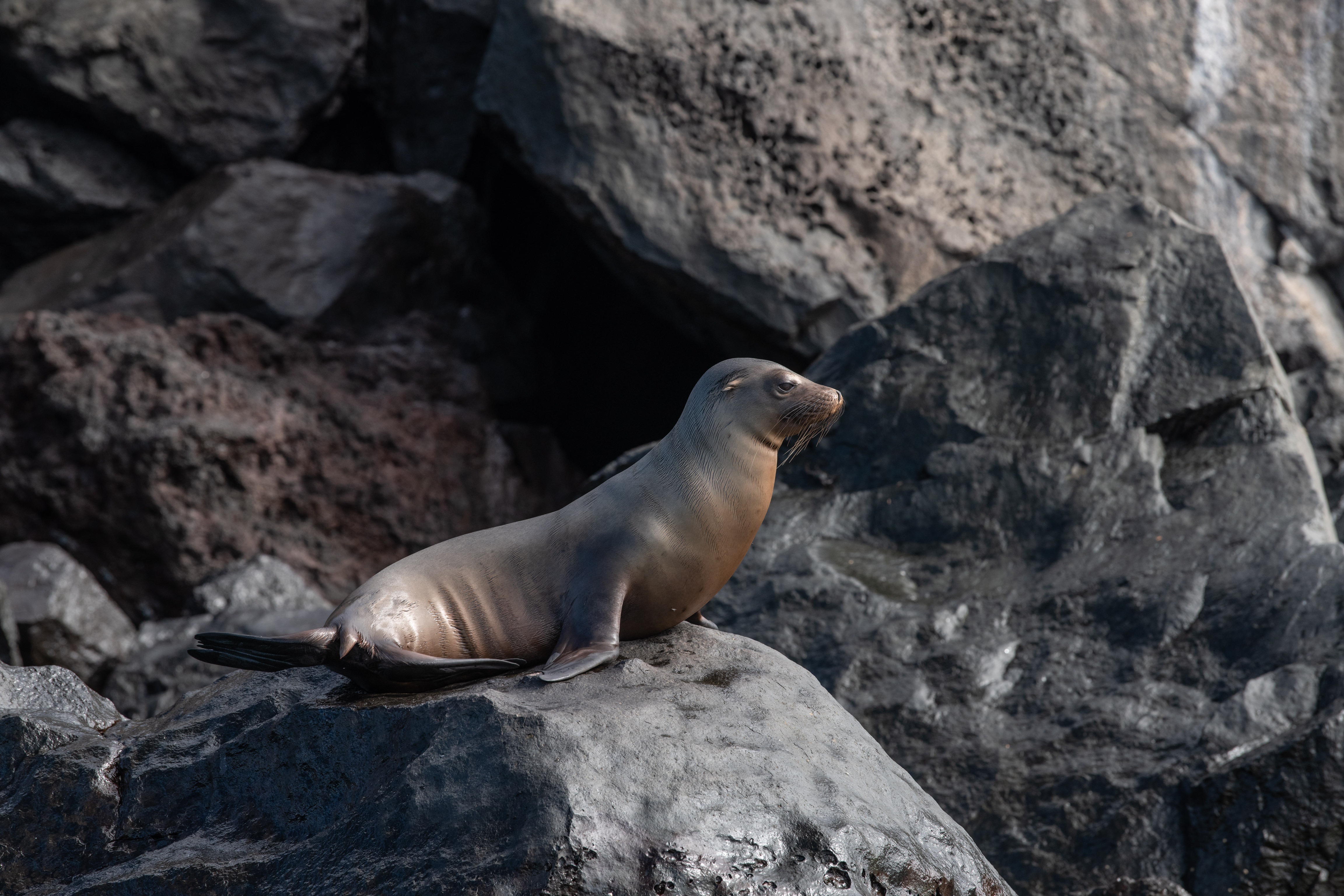
Sea Lion
I visited Alaska last year, and during that trip I took a sightseeing boat tour from Valdez. There were lots of Steller Sea Lions, and those adults were huge. In contrast, these Galapagos Sea Lions were relatively small, with adults only about 4-5 feet long. We were able to approach some of them quite closely; they just ignored us.
 |
| Flightless Cormorants |
The Flightless Cormorants were pretty common. These swam right past our zodiac when we were looking at some other birds. During some of our landings we walked by them on the path; they mostly ignored us.
Marine Iguana
Marine Iguanas were everywhere. They were on land sunning themselves. They were swimming. They were sometimes in the way when we were walking ashore. Often they congregated in groups of a dozen or more.
Sea Lion
Galapagos Penguin
We saw penguins only once. This was the best shot I could get from the zodiac that was moving up and down in the waves. It was overcast and breezy so the zodiac driver did the best he could to keep us from drifting away. Shooting these birds was a challenge.
 |
| Flamingo |
There was a handful of Flamingos standing on the beach for one of our landings. I think these birds are responsible for many gigabytes of storage taken up by photos of them. The other passengers surrounded the birds, so I had to pick a spot to get my shots without people in them. This was a high surf water landing during which I had to pick my moment to jump in/out of the zodiac while the waves were out.
So, we saw lots of wildlife, lots of volcanic features, and enjoyed a trip unlike any I’ve every made.